What is navigation?
Dear visitor,
Feel free to turn off your GPS or Google Earth. You have arrived, and here you will discover how people truly navigated for centuries.
Navigation is the knowledge and skill to determine the geographical position of a ship and then guide it safely and purposefully to its destination. Every place on Earth is defined by two coordinates: latitude and longitude. Latitude is measured north or south from the equator; longitude is measured east-west from an agreed prime meridian, today that of Greenwich.
This exhibition presents instruments, charts, and books used in seafaring from the mid-15th to the mid-20th century, with a focus on ocean navigation as developed by Portuguese and Spanish mariners. Earlier navigation relied on coastal features, currents, stars, and the sun, usually in sailing areas where land was never far away. The Phoenicians and Greeks also laid the foundations of Western navigation methods.
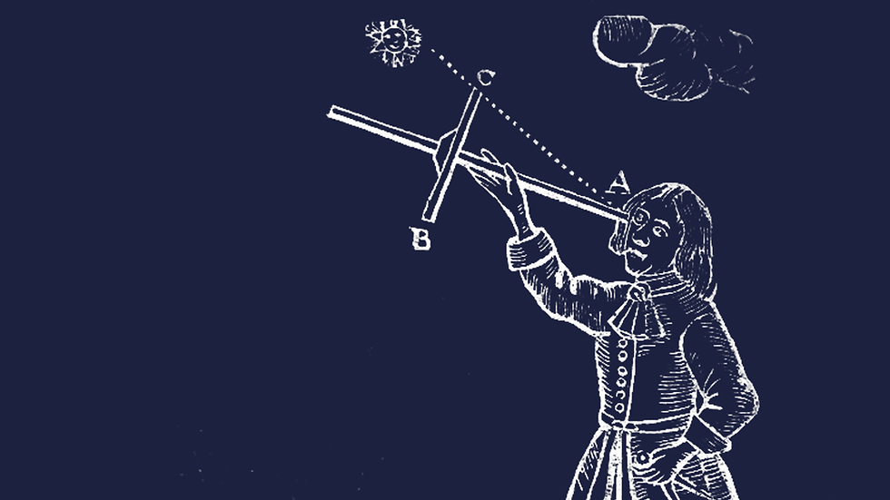
From around 1450, European explorers dared to venture onto the open ocean. Driven by trade, power, religion, and scientific curiosity, rulers founded navigation schools and encouraged new techniques. In the Northern Hemisphere, the altitude of the Pole Star provided a direct determination of latitude. South of the equator, navigators used the sun at its highest point,together with pre-calculated declination tables.
Because longitude could not yet be determined reliably, sailors followed the so-called “latitude sailing”: first sailing north or south to the correct latitude, then east or west by compass and estimated distance. Maps evolved from simple coastal sketches into the reliable Mercator projection.
The major breakthrough came only in the 18th century with accurate timekeeping. Thanks to chronometers, sextants, and astronomical calculations, it finally became possible to determine longitude accurately. Classical navigation reached its peak—until it was surpassed in the 20thcentury by electronic systems and satellite navigation.
What is shown here is the result of a collection with fascination for the ingenuity of earlier scientists and the courage of seafarers. It is the foundation on which modern technology rests.
Our proud sponsors


Curatorship and research
Carl Dierickx, curator
Koenraad Van Cleempoel, co-curator
Bart De Smet
Koen De Vriese
General coordination
Wim Van Erck - VNSM
Exhibition design
Carl Dierickx
Core collection
NavigArte Collection
Loans
MAS - Museum Aan de Stroom Antwerpen
Landtmeters BV
François Clement
Koen De Vriese
Webdesign and Digitalisation
Graphic design
Els Van Hoof
Technical support
MAP - Mercator Sint-Niklaas
Dirk Gaudaen - VNSM
Philip Streitz - VNSM
Marc Dewitte - VNSM
Karel Stoffelen - CEPA
Partners & sponsors