Display 1: Orientation before the compass

On your way here, you probably didn't notice the pigeons flying along the road or perched on the church towers. Yet, just like clouds and coastlines, birds played a crucial role in wayfinding for centuries.
The first mariners stayed close to the coast. They oriented themselves by recognizable coastal contours, observed clouds over land, and followed the flight of coastal birds. Some birds, like the tern, even possess a natural sense of direction, resembling a built-in compass.
From ancient times, sailors began recording their knowledge. Greeks, Phoenicians, and later Romans wrote detailed descriptions of coasts, harbors, currents, and distances. These writings, called periploi, can be considered the precursors of our modern mariner's guides and pilot books. Sometimes even physical models of coastlines were created, such as those of Greenland.
In the 11th century, the Vikings did not yet possess a magnetic compass. They used a solar compass to navigate westward at the same latitude. In the Arab world, the kamal, a simple instrument for measuring the altitude of the North Star, had already been used earlier.
Only from the 14th century onward did Western European navigators dare to sail further from the coast. By observing the night sky, and especially the Pole Star, they could determine their latitude. This paved the way for great seafaring and voyages of discovery.

1.2
Viking Sun Compass, 3D printed reconstruction, 2020
Maker:
NavigArte
Collection:
NavigArte
The sun compass was the only method Vikings had to maintain their course during westward voyages. The shadow of the alidade had to be kept aligned with a line drawn on the floating compass, as established in the departure harbour around midsummer. Reconstruction based on the sun compass found in Uunartoq, Greenland.

1.3
Manuscript textbook on teaching navigation, logbook keeping, and chart making, 1791
Displayed here is a manuscript Plane-chart of Western European waters.
Maker:
J. Breckon, UK
Collection:
NavigArte
Manuscript textbook on teaching navigation, logbook keeping, and chart making, 1791
Displayed here is a manuscript Plane-chart of Western European waters.

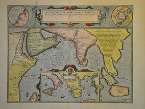
1.4
Le Petit Flambeau de la Mer, Ou le veritable guide des pilotes cotiers, 1731
Maker:
René Bougard, Le Havre
Collection:
NavigArte
This is a pilot book rather than an atlas, by René Bougard, a French hydrographer from Le Havre. It contains numerous woodcuts of coastal profiles and harbours. Widely used book in nautical schools and on board ships. (First edition 1684)


1.8
Kamal or Al-Kemal
Maker:
Anonymous, Abu Dabi
Collection:
NavigArte
Kamal of Al-Kemal, 9th century, 20e cent. replica
Replica of an Arab instrument for determining latitude, developed in the 9th century. From the 9th century onwards, Arab navigators used the simple Kamal or Al-Kemal to recover their latitude relative to their home port by measuring the altitude of the North Star above the horizon. For each port, a knot was tied in the cord, which was held between the teeth to indicate the latitude at which one had to sail east or west to reach that port.

Our proud sponsors


Partners & sponsors