Display 7: Sextant

The sextant became the standard instrument for astronomical navigation at sea in the second half of the 18th century. It built on the octant but offered a greater measuring range and even higher accuracy.
The name sextant refers to the arc of one sixth of a circle (60°), which, thanks to mirror reflection, could be used to measure angles of up to 120°.
Like the octant, the sextant uses a movable index mirror and a semitransparent horizon mirror. By precisely aligning the reflected image of a celestial body with the horizon, the mariner could read the altitude very accurately on the finely graduated scale arc. Measurements could be made both during the day, using sun glasses, and at night using the moon, stars, and planets. (.) A naval disaster in 1707 and a contest organized in London in 1714 led to enormous advances in available instruments and new nautical tables. From the end of the 18th century, the sextant, in combination with reliable chronometers, made it possible to determine not only latitude but also longitude with great precision.
Well into the 20th century, the sextant remained an indispensable instrument aboard ocean-going vessels. Even in the age of electronic navigation, it is still learned and used as a reliable, self-contained aid independent of external power sources.
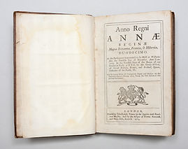
7.1
Act of Longitude by Queen Anne, 1714
Maker:
John Baskett, London
Collection:
NavigArte
After the naval disaster of 1707, in which around 2,000 sailors lost their lives due to navigational errors, a prize of £20,000 was announced and laid down in this Act by the Board of Longitude. A solution had to be found for determining longitude at sea. Clockmaker John Harrison and the astronomer Tobias Mayer (through his widow) received the largest share of this prize.
7.2
Tabulae motuum solis et lunae, novae et correctae, 1770
Maker:
Tobias Mayer and, Marbach am Neckar
Collection:
NavigArte
The Moon acts as a clock in the firmament. With these newly measured lunar ephemerides, the lunar distance method could be applied at sea to determine longitude. Published by Nevil Maskelyne and the Board of Longitude in London. He also discribes the reflecting circle of the Borda type to measure large angles.


7.4
French reflecting mirror (repeating circle), Borda type, No. 50, 1819
Maker:
François-Antoine Jecker, Paris
Collection:
NavigArte
Tobias Mayer proposed this type of instrument for measuring lunar distances relative to a star or planet in order to determine longitude at sea. Jecker was a pupil of Jesse Ramsden.

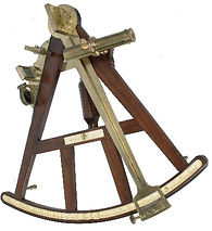
7.5
14 1/2 Inch vernier-type sextant,1770
Maker:
Jesse Ramsden, London
Collection:
NavigArte
James Cook tested during his first ( 1768-71) and his second voyage (1772-75) in the Pacific Ocean mainly the Lunar Distance-method. On his third voyage (1776-1779), and maybe already on the second voyage, he tested this very early type of sextant. He concluded afterwards that the sextant used in combination with a chronometer was more accurate than the lunar distance method for determining longitude at sea.
This sextant was still hand-engraved.


7.8
7 Inch Brug- of Bridgeframe sextant Nr. 1226, 1794
Maker:
Jesse Ramsden, London
Collection:
NavigArte
One of the very fine and accurate sextants of the famous instrumentmaker Jesse Ramsden,
who, with an automatic engraving and dividing machine, greatly improved the accuracy of the scale.
This is the Bridge-frame model, to improve the stability of the frame.


7.11
11 ¾ Inch Pillar-frame Sextant of Troughton, No. 119 on its own tripod, 1795
Item 7.12 : Artificial horizon by Troughton & Simms, 1850
Maker:
Troughton, London
Collection:
NavigArte
A large sextant, pillar-frame type, on a heavy tripod. Used for surveying. Because there is no proper horizon on land, an artificial horizon was also used, such as a bath filled with mercury, which served as a perfectly horizontal mirror. This allowed the measurement of the double angle between the celestial body and its reflection, and then divided by two.


7.15
Plan of wrecks around the Isles of Scilly
Maker:
Admiralty, London
Collection:
NavigArte
Plan of wrecks around the Isles of Scilly with the wreck of the HMS Association highlighted on it
On 22 October 1707, Admiral Sir Cloudesley Shovell's flagship, HMS Association, was wrecked along with three other ships off the Isles of Scilly. This shipping disaster, one of the worst in British naval history, was the result of navigational errors, mainly due to the inability to determine the exact longitude at sea.
The disaster brought the problem of longitude determination to national attention, eventually leading to the Longitude Act of 1714, which offered a substantial prize of £20,000 for a solution.

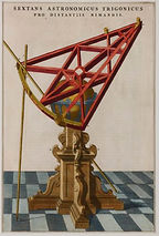
7.16
Sextans Astronomicus Trigonicus pro distantiis rimandis (in Atlas Maior), 1664
Maker:
Joan Blaeu, Amsterdam
Collection:
NavigArte
This print of a very early sextant was designed by Tycho Brahe in 1584 and had a radius of 155 cm. Johannes Blaeu published this design in his Atlas Maior as an appreciation for both his father Willem and Tycho Brahe, where his father was an apprentice.
Our proud sponsors


Partners & sponsors