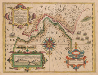
Street of Magellan
from Hondius/Mercator Atlas
Type of object:
Maps and globes
Time period:
Denemarken & Belgie
Place:
Amsterdam
Date:
1613
Maker / Author:
Hondius in Mercator atlas Atlas’ Sive cosmographicae meditationes’
Publisher / Printer:
Hondius
Dimensions:
35.5 x 45.7 cm
Material:
Coloured Copperprint on paper
Graduation:
Inscription:
Exquisita & magno aliquot mensium periculo Lustrata et iam retecta Freti Magellanici facies
Provenance:
References:

Description
The map was published in Gerard Mercator’s “Atlas sive Cosmographicae Meditationes…” out of Amsterdam in 1613. Centered on an exquisite compass rose, this map bears a southern projection with North pointing towards the bottom of the map. While the Strait of Magellan is the focus of the map, one must note the southern land titled Terra Del Fuogo is mapped with a mountainous and well defined coastline extending into the unknown southern continent. This map predates the discovery of the route around Cape Horn by Schouten and LeMarie in 1616 that ultimately proved that Terra del Fuego was an island. Not only is this map the first map of the Strait of Magellan to appear in a commercial atlas, it’s one of a few sea charts produced by Mercator with depth soundings and horizon views. From end to end, the strait is loaded with various soundings and about 17 place names. The lower left portion of the map features a view of the entrance to the Strait, likely derived from earlier Dutch books. Several sailing ships, a large sea monster and a sea lion family embellish the map. The title cartouche is that of early Baroque style and is flanked by two penguins.
Additional information


